
Last updated: October 6, 2026
Short answer: A San Antonio yard drainage plan starts with a verified outfall, not a French drain. Before choosing any device, name where the water comes from, which elevations control its path, what the soil will accept, and where collected flow may lawfully go. Lots here range from deep clay to shallow fractured limestone or fill over caliche.
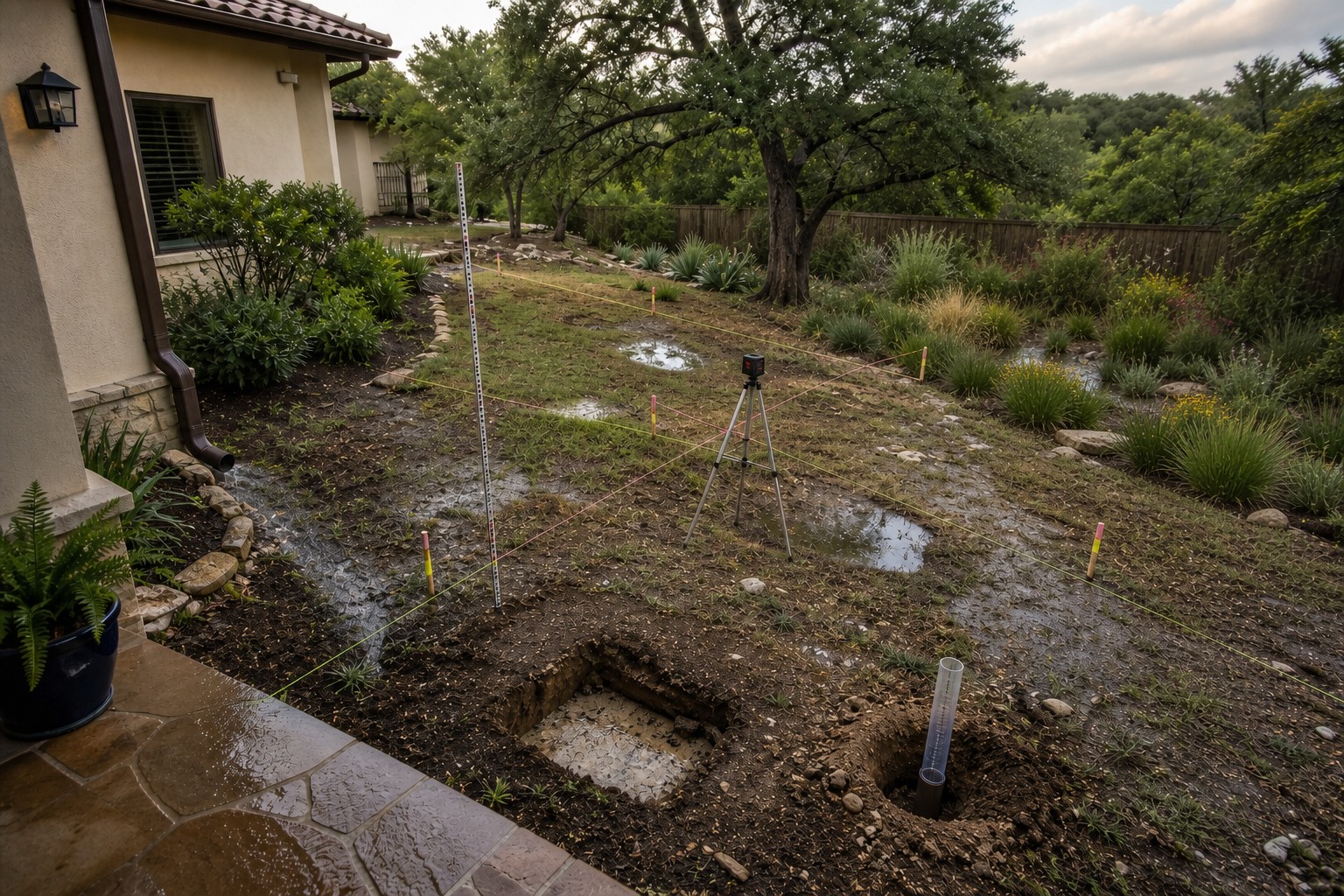
A French drain is a component, not a diagnosis. So are a catch basin, dry well, rain garden, swale, channel drain, and load of topsoil. None can be selected responsibly until the property owner knows where the water originates, which elevation controls its path, what the soil profile will accept, and where the collected flow may safely go.
San Antonio makes those questions unusually site-specific. One lot may have deep clay, another shallow fractured limestone, and another compacted construction fill over caliche. A property may be inside City limits, outside the City in unincorporated Bexar County, within a historic overlay, near a mapped floodplain, or above a regulated aquifer zone. The device should come last.
Where should yard drainage water go in San Antonio?
Start at the downstream end and mark an exact receiving point: an on-property vegetated area with demonstrated capacity, an approved drainage feature, or a designed storage-and-release system. Water sent to the street reaches creeks and rivers, not a sanitary sewer. If the route crosses a drainage easement, right of way or neighboring land, settle approvals before excavating.
Start at the downstream end. A pipe with no verified fall and lawful outlet simply moves the uncertainty underground. Mark the exact receiving point: an on-property vegetated area with demonstrated capacity, an approved drainage feature, a designed storage-and-release system, or another location accepted for the project by the controlling authority.
Then walk uphill. Trace every surface that drains toward the problem: roof planes, downspouts, patio, driveway, neighboring grade, air-conditioning condensate, irrigation, pool equipment, bare soil, retaining features, and existing swales. One puddle may have three contributing areas, each arriving at a different rate.
The San Antonio River Authority notes that stormwater entering the street system flows to creeks and rivers rather than a sanitary sewer. That makes sediment, fertilizer, pet waste, oil, and construction debris part of the outfall decision. “Toward the curb” is not a complete water-quality plan.
If the only apparent route crosses a drainage easement, public right of way, neighboring land, steep bank, protected feature, or buried utility, stop at concept level. San Antonio defines an encroachment broadly as a physical obstruction or object placed in, under, or over a City street, alley, or drainage easement in which the City has an interest. Approval questions belong before excavation.
How do I diagnose a drainage problem before regrading?
Film it during a safe rain. Dry-yard photos miss flow velocity, sequence and duration, so record short clips from fixed points showing when each downspout activates and which low point fills first. Afterward, note when standing water disappears. San Antonio Public Works offers a residential site-visit route, and its public maps include one-foot contours for screening.
Dry-yard photographs miss flow velocity, sequence, and duration. During a safe rain event, record short clips from fixed points showing when each downspout activates, where sheet flow concentrates, which low point fills first, where water crosses a walk, and whether the receiving area backs up. Never enter moving floodwater or work during lightning.
After rain ends, return at consistent intervals. Mark the puddle outline and water depth without disturbing it. Note the time when standing water disappears, where fine sediment settles, where mulch moved, and whether gray soil, algae, cracking, or a buried hard layer becomes visible. Repeat after a second event if the first was unusually small or extreme.
Separate chronic wetness from a single blockage. A crushed downspout extension, buried outlet, irrigation leak, uphill hose discharge, or clogged area inlet can mimic a grading failure. Shut off controllable sources and inspect accessible components before proposing earthwork.
San Antonio Public Works provides a residential site-visit route for guidance on property protection, retrofits, and drainage improvements. Its public map resources include one-foot contours and hydrologic features. Use those as screening evidence, not as a replacement for a boundary and elevation survey when the tolerances or consequences are tight.
Turn water movement into an elevation ledger
Establish one stable benchmark that construction will not remove. Record spot elevations at the foundation, thresholds, downspout discharge, patio and walk edges, top and bottom of slopes, puddle bottom, swale invert, property boundaries, easements, inlet rims, and proposed receiving point. Include both existing and proposed values.
A dimensioned plan should show the whole tributary area, not only the wet patch. Roof plans matter because a small side yard may receive runoff from a large roof plane. Paving added upstream can change both volume and arrival speed. The City’s stormwater utility uses impervious cover in its rate structure precisely because hard surfaces affect runoff.
Do not promise a universal minimum slope without the surface, distance, tolerance, and receiving condition. A steep line may accelerate erosion; a shallow line may fail when construction variation consumes the available fall. The design needs a profile that can be set out and checked in the field.
| Measurement | Question it answers | Common false conclusion |
|---|---|---|
| Foundation-to-low-point elevation | Can surface grading protect the structure without creating a new basin? | Adding soil at the wall always helps |
| Low-point-to-receiver fall | Is gravity conveyance physically available? | A buried pipe creates slope |
| Contributing hard-surface area | How much fast runoff reaches the zone? | The puddle’s square footage equals its drainage area |
| Inlet and overflow elevations | What happens when the primary route is full? | A grate prevents flooding |
How do I test whether my soil drains well enough for a rain garden?
The San Antonio River Authority’s rain-garden screen is simple. Fill a twelve-inch test hole, let it drain, then fill it again while the soil is saturated. At least one-half inch of drainage in an hour on the second fill is adequate, and a rain garden should hold no standing water after 24 hours. Locate utilities before digging.
A topsoil label does not describe the profile below it. The local soil guide can frame the possibilities, but the drainage decision needs property-specific evidence. Identify fill, clay, caliche or limestone, roots, buried debris, and seasonal wetness at the actual device elevation.
For a residential rain-garden screen, the San Antonio River Authority instructs owners to fill a twelve-inch test hole, let it drain, then fill it again while the soil is saturated. It describes at least one-half inch of drainage in an hour on the second fill as adequate and says a rain garden should have no standing water after 24 hours. Those criteria belong to that rain-garden method; they are not a universal approval for every infiltration system.
The River Authority’s regional technical manual adds the larger local context: Bexar and nearby counties have high concentrations of hydrologic Group C and D soils with low or very low infiltration when wet. It says local infiltration practices may need careful variation, soil media, or underdrains. A dry test over fractured limestone can also behave differently from clay-filled fractures after repeated storms.
Document hole depth, dimensions, soil layers, first and second fill, water-level change, timing, weather, and location. Do not excavate until utilities are located. If the test exposes voids, shallow bedrock, unexpected fill, sewage odor, persistent groundwater, or structural risk, move from landscape diagnosis to the appropriate technical professional.
Match the intervention to the failed function
A broad swale conveys shallow surface flow and remains visible for inspection. A rain garden stores and filters a defined volume where soil and setbacks permit. A surface inlet collects water at a low point but still needs a verifiable pipe route and outlet. Regrading removes a depression or reestablishes positive surface flow. Roof capture reduces the water entering the yard but needs storage, overflow, and maintenance.
A subsurface aggregate drain is most useful when it intercepts or conveys water through a designed profile; it should not be used to hide an unknown outlet or compensate for impossible elevations. A dry well or other infiltration structure needs soil and groundwater evidence, pretreatment, access, overflow, and jurisdictional acceptance.
Keep structural problems separate. Foundation movement, retaining-wall pressure, pool stability, roadway drainage, creek-bank erosion, or recurrent building entry is not merely a planting-bed decision. The permit reference is a starting point, but current City, county, floodplain, utility, and professional requirements control.
Do aquifer zones or historic districts affect drainage work in San Antonio?
Yes, both can. River Authority guidance allows rain gardens in the Edwards Aquifer Contributing Zone, but one over the Recharge Zone must be lined or sit within a treatment train of best management practices. Properties under a historic zoning overlay need a Certificate of Appropriateness for exterior changes, side and rear yards included. Verify the mapped parcel first.
The River Authority’s residential guidance says rain gardens may be used in the Edwards Aquifer Contributing Zone, while a rain garden over the Recharge Zone must be lined or be part of a treatment train of best management practices. Do not guess the zone from neighborhood name or visible limestone; verify the mapped parcel and current agency requirements.
Historic review is a different boundary. San Antonio’s Office of Historic Preservation says exterior modifications on properties with a historic zoning overlay require a Certificate of Appropriateness, including side and rear yards not readily visible from the street. A drainage improvement that changes grade, site walls, paving, or visible landscape features may therefore need early case-manager review.
These are City of San Antonio sources. A mailing address that says San Antonio can still sit in another municipality or unincorporated Bexar County. Identify the governing jurisdiction before relying on City process, and separately check HOA documents, recorded easements, plat notes, and utility rights.
Keep clean runoff clean during construction
Excavation can turn a small yard project into a sediment source. Phase work so disturbed soil is open for the shortest feasible time. Protect the downstream edge before excavation, keep stockpiles out of flow paths, stabilize inlets and outlets, and prevent rinse water, fuel, concrete residue, soil, and loose aggregate from entering the street system.
Preserve live-oak roots and existing stable vegetation where possible. A new swale that cuts major roots or changes grade over a root zone may trade drainage evidence for tree damage. Show protected areas and equipment access on the whole-property plan.
San Antonio’s property maintenance code requires premises to be graded and maintained to prevent soil erosion and stagnant water, with an exception for approved detention, retention, filtration areas, and reservoirs. The word approved matters: a functioning designed basin should not be confused with neglected standing water.
Acceptance needs a storm, not a hose alone
A hose can confirm that an inlet is open and that water appears at an outlet. It cannot reproduce roof timing, whole-yard sheet flow, saturated native soil, or downstream backup during a storm. Use it as a commissioning check, then retain a weather-dependent acceptance item.
During the first meaningful event, revisit the same camera points. Record rainfall source and timing, water spread and depth, flow direction, inlet capture, overflow route, erosion, sediment, outlet velocity, neighboring effects, and drawdown. Inspect again after the ground has dried for settlement, exposed fabric, displaced rock, scour, dead plants, cracked soil, and blocked openings.
The final bank should contain the prework storm film, benchmark and elevation table, contributing-area plan, soil and percolation record, jurisdiction responses, approval documents where applicable, utility locate, concealed-stage photographs, installed profile, maintenance instructions, and post-storm acceptance. That record makes future diagnosis possible without digging first.
San Antonio grading-and-drainage Sources
- City of San Antonio Public Works: drainage review, residential site visits, contours, hydrology, and flood resources
- City of San Antonio Property Maintenance Code: grading, erosion, and stagnant-water requirements
- City of San Antonio: drainage-easement and right-of-way encroachment process
- City of San Antonio Office of Historic Preservation: exterior work and Certificate of Appropriateness boundary
- San Antonio River Authority: residential rain-garden siting, saturated-soil test, drawdown, and Recharge Zone conditions
- San Antonio River Authority: regional C/D soils, infiltration limits, and low-impact development options
- San Antonio River Authority: local runoff, pollutant pathways, and low-impact development principles
What causes yard drainage problems in San Antonio?
Usually a mix of water sources and what is under the lawn. Roof planes, downspouts, driveways and a neighbor’s grade all push water toward one low spot, and the ground may be deep clay, shallow fractured limestone or fill over caliche. The soil decides how fast that water can leave.
Our soil guide shows how caliche and thin topsoil change what a yard can absorb.
Will a French drain fix a wet yard in San Antonio?
Not by itself. A French drain is one component, and it only works if it has a verified fall and a lawful place to discharge. A pipe with no outlet just moves the puddle underground. Name the receiving point first, then choose the device that gets water there.
If the fix involves new walls or grade changes, check when San Antonio requires a permit before you dig.
Does the City of San Antonio help with residential drainage questions?
San Antonio Public Works offers a residential site-visit route for guidance on protecting property and fixing drainage, and its public maps show one-foot contours and hydrologic features. Use those as screening evidence. They do not replace a boundary and elevation survey when tolerances are tight.
Bring photos of the yard during rain, and see how we plan landscape layouts around drainage.
Where does stormwater from a San Antonio yard end up?
Stormwater that enters the street system flows to creeks and rivers, not to a sanitary sewer, according to the San Antonio River Authority. That makes sediment, fertilizer, pet waste and construction debris part of every outfall decision, so sending runoff toward the curb is not a complete plan.
Low-water beds also help hold runoff on site, which is covered in our xeriscaping guide.